
Wet, colder than average with a lack of any warm spell - a disappointing month.
Finally a month in 2017 that finishes colder than average, but coupled with the fact that it was also wet with rain frequent, especially in the second half, when it became increasingly unsettled (coinciding with the start of the school summer holidays), you could be excused for wondering if summer was ever going to arrive.
The first half of the month wasn't actually that wet (24.5 mm upto the 18th), although there was still some rain on most days. Even though low pressure tended to dominate, there were transitional days of high pressure, but after a brief, dry, sunny and warmer spell 16-18th, when high pressure did assert itself over the UK, the month became increasingly unsettled and the rain heavier, which at the month's end fell in the form of showers. As with the start of the month, it was also much cooler at the end of the month.
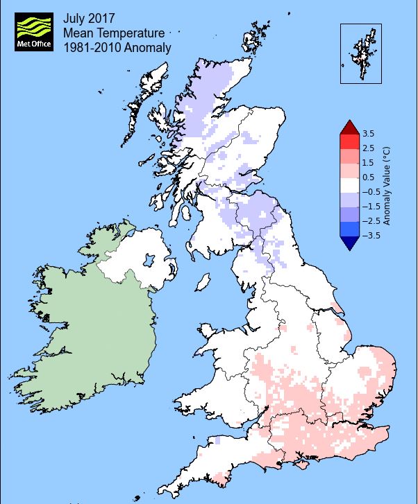
Whilst both the mean minimum and maximum temperatures were below average, it was the maximum that showed the greater departure from the norm' and only five days attained 20°c (four reaching 70°f) - and the usual culprit of the Jet Stream was to blame, creating the more mobile westerly conditions.
Thunder was heard on one day, 19th, at the breakdown of the 'warm spell' and a 'day of fog' was recorded once, 22nd, when very heavy rain in the morning was quite grim and reduced the visibility significantly.
MSLP of 1011.5 Mb was -3.0 Mb below the local average for July with low pressure very much in the ascendency throughout the month, especially during the second half.
Overall a mean minimum of 10.28°c and a mean maximum of 18.59°c saw the temperature 0.7°c below the 1981-2010 average and it was the coldest since 2015. The highest maximum temperature recorded was 25.6°c (18th), the lowest minimum 4.7°c (12th).
Rainfall of 103.4 mm (Crosby Ravensworth School 112.3 mm - Castlehowe Scar 141.1 mm - Reagill ??? mm) made it the wettest July since 2013 (5 having been drier and 5 having been wetter of the 11 now recorded) and was 97.6% of average for 2007-16 - it should be noted that the decade 2007-16 has been notably wetter than the 30 year long term average and thus many stations with such long records have been wetter than average.
Locally, rainfall percentages were above average, although generally not significantly, but as usual there were a few exceptions: Kirkby Thore again had over double its average and yet a few such as Haresceugh Castle fell below average.
At the Met' Office site at Newton Rigg, 94.0 mm (133.9%) made it the wettest since 2012 and in a series back to 1900 there has been 89 drier and 25 wetter (3yrs of missing data). In a series back to 1951 a mean temperature of 14.2°c is the coldest since 2015 with 23 having been colder, 40 warmer and 2 having the same mean temperature (and 1yr of missing data).
Figures from the Environment Agency�s rainfall sites were, (figure in brackets being the monthly average for 1961-90) �Data kindly provided by the Hydrometry and Telemetry team of the Environment Agency (Penrith)�:
Kirkby Thore 87.4 (39.8 mm)
Haresceugh Castle (Kirkoswald) 68.56 mm (78.2 mm)
Brothers Water 158.19 mm (142 mm) and
270.2 mm at Seathwaite Farm (Borrowdale - 204 mm [average for 1981-2010])
1st - 2nd The month opened with a slight ridge of high pressure (HP) over the UK, although low pressure (LP) was always nearby and which resulted in dry, but generally cloudy days with limited sunshine. Mild by night, but day-time temperatures were below 17°c.
3rd - 15th It all then became a little mixed - generally uninspiring, not especially warm nor wet, but with few good days. Typically it was a case of a more mobile westerly flow pushing LP systems towards the UK on a regular basis, but with transitional days of HP inbetween.
Consequently temperatures tended to be below the seasonal average and the only day to top 20°c was the 6th (22.4°c), but which also had a humid feel in a SSE'ly with a hazy sunshine. The better days during the period, those with sunshine, were the 8th, 12th (which just fell short of 20°c) and to a lesser degree, the 13th.
Otherwise it was a case of being generally cloudy, some occasional brighter moments, but also rain on occasions and temperatures more typically 17-18°c. Fortunately the main belts of rain came overnight, 10th and the 11th, with the days having more rain during the morning and then showing a slight a gradual improvement during the afternoon.
As already mentioned the 12th was one of the better, 'transitional days' under a ridge of HP. With clearing skies and a NW'ly flow, we had the rarity of a the temperature dropping below 5°c, the last occasion being the 3rd June. It certainly felt much cooler, but was more than compensated by a decent day.
Whilst the temperature did not drop as low, the 13th also started chilly. The day itself was decent enough with sunshine into the afternoon, but the HP was being shunted away east by another LP system approaching from the west. This gave a brief spell of rain (3.3 mm) late in the evening as the associated cold front moved through and then with another brief ridge of HP, the 14th was an Ok'ish sort of day, before a new frontal system brought more rain in the evening and overnight into the 15th - all very mobile, all very transitional.
The period finally came to an end on the 15th with a poor day that was overcast and with bouts of light drizzle as the frontal system became slow to clear the UK, but which only gave a mere drop of 0.2 mm.
16th - 19th It then turned warm as HP to the SW of Eire moved east and became established over the UK.
The fine and sunny weather was short lived, nothing unusual in that this summer, but it gave another tantalising taste of what summer look likes. Whilst the 16th saw sun throughout the day, a fresh breeze kept a lid on the temperature, but for 'The Open Gardens' it was lovely, the next few days saw the heat ratchet up.
Virtually clear skies on the 17th and a temperature of 22.3°c was ideal, but then totally clear skies on the 18th saw the mercury rise to a month's high of 25.6°c (78.1°f). It certainly felt hot, but was tempered slightly by a steady ESE'ly breeze - but what a couple of fine days.
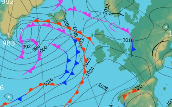
Now the issue became one of 'will we get any thunderstorms or not?' as LP in Biscay pushed a warm front and then a trough line very slowly north during the 18th. The forecast kept changing, but eventually it arrived in the evening. at first a few. brief rumbles and then we had a good spell of thunder and lightning for 30 minutes from 1855 hrs which was accompanied by heavy rain that gave 8.9 mm.
 1800 Hrs 19th - the low pressure system surrounding the UK and pushing north that brought the thunder on the 19th
20th - 25th The set-up now became westerly and more mobile, bringing a series of LP to the UK and consequently it all became a little unsettled.
The 20th was transitional behind the fronts of the 19th, then the 21st was overcast with a few light spells of rain, before the grim day on the 22nd. LP sat over Eire had deepened and become stationary and now the cold front that was wrapped around its centre moved north, bringing a period of heavy rain. Rain fell from 0700 hrs and became quite intense during the morning and kept going through to 1300 hrs with a gradual improvement that ended with a sunny evening. However, the rainfall saw 14.6 mm credited back to the 21st to make it the month's wettest day with 14.5 mm credited to the 22nd.
LP systems then surrounded the UK and brought a mixed bag on the 23rd which started sunny before rain arrived in the afternoon and whilst the 24th started overcast and dull the fronts moved east and the day became quite pleasant with plenty of sun and consequently managed to reach 20.4°c, it was also (technically) the only dry day after the 18th.
A brief ridge of HP saw the period finish with another dry day (but rain before 1000 hrs on the 26th would be credited back to the 25th!), not as sunny as the 24th, being mainly overcast until a fine end to the day.
26th - 31st Low pressure remained very much in the ascendency, but now it was the same area of LP for the entire period. Rain was still a frequent visitor, albeit mainly in the form of showers and it also became even cooler.
A large and deep area of LP developed out in the Atlantic to the west of Eire and just sat there, becoming virtually static and dominant.
The LP pushed a fairly constant stream of fronts and troughs over the UK all blown in on a fresh breeze which saw the temperatures struggle by day-time, typically in the range of 16-17°c.
It wasn't all about the showers though as there were a few sunny intervals, but it was 'few' and so ended what in may have only just been worse than average, but in reality was very disappointing.
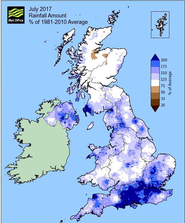
Rainfall totalled 103.4 mm for the month, with rain recorded on 22 days of which 20 were 'Wet days' (1.0mm +).
The Mean Temperature for the month was 14.44°c -- The Mean Max' was 18.59°c -- The Mean Min' 10.28°c.
We had 0 Air Frosts in the month (year 32) -- Grass frosts totalled 0 (year 67).
The 1 foot soil temp ranged from a low of 14.0°c on the 1st to a high of 17.2°c on the 19-20th -- with a monthly mean of 16.1°c
The 1 meter soil temp ranged from a low of 13.0°c on the 1st - 4th to a high of 14.5°c on the 28th -- with a monthly mean of 13.8°c
COMPARISONS:-
* July 2017 rainfall was 97.6% of the average for 2007 - 2016
* July 2017 was 0.41°c colder than the average for 2009 - 2016 and 0.7°c colder than the local long term average 1981-2010
* This makes the Jan' to July period of 2017 some 0.9°c warmer than the average for 2009-16 and with 90.4% of average rainfall for 2008-16
JANUARY 2010
FEBRUARY 2010
MARCH 2010
APRIL 2010
MAY 2010
JUNE 2010
JULY 2010
AUGUST 2010
SEPTEMBER 2010
OCTOBER 2010
NOVEMBER 2010
DECEMBER 2010
JANUARY 2011
FEBRUARY 2011
MARCH 2011
APRIL 2011
MAY 2011
JUNE 2011
JULY 2011
AUGUST 2011
SEPTEMBER 2011
OCTOBER 2011
NOVEMBER 2011
DECEMBER 2011
JANUARY 2012
FEBRUARY 2012
MARCH 2012
APRIL 2012
MAY 2012
JUNE 2012
JULY 2012
AUGUST 2012
SEPTEMBER 2012
OCTOBER 2012
NOVEMBER 2012
DECEMBER 2012
SUMMER 2012
REVIEW OF 2012
JANUARY 2013
FEBRUARY 2013
MARCH 2013
APRIL 2013
MAY 2013
JUNE 2013
JULY 2013
AUGUST 2013
SEPTEMBER 2013
OCTOBER 2013
NOVEMBER 2013
DECEMBER 2013
REVIEW OF 2013
JANUARY 2014
FEBRUARY 2014
MARCH 2014
APRIL 2014
MAY 2014
JUNE 2014
JULY 2014
AUGUST 2014
SEPTEMBER 2014
OCTOBER 2014
NOVEMBER 2014
DECEMBER 2014
WINTER 2014
REVIEW OF 2014
JANUARY 2015
FEBRUARY 2015
MARCH 2015
APRIL 2015
MAY 2015
JUNE 2015
JULY 2015
AUGUST 2015
SEPTEMBER 2015
OCTOBER 2015
NOVEMBER 2015
DECEMBER 2015
REVIEW OF 2015
JANUARY 2016
FEBRUARY 2016
MARCH 2016
APRIL 2016
MAY 2016
JUNE 2016
JULY 2016
AUGUST 2016
SEPTEMBER 2016
OCTOBER 2016
NOVEMBER 2016
DECEMBER 2016
REVIEW OF 2016
JANUARY 2017
FEBRUARY 2017
MARCH 2017
APRIL 2017
MAY 2017
JUNE 2017
OTHER ARTICLES
The Oldest Inhabitant
An Inch Of Scotch Mist
© Darren Rogers 2010-17
Want to comment on this site? email